A Guide to the Trails of Mt. LeConte
Parking of any kind in non-designated areas, including roadsides, is no longer permitted in Great Smoky Mountains National Park. All available parking spaces at Mt. LeConte's trailheads are first-come first-served. The NPS will be issuing warnings, citations, or towing vehicles parked "out of bounds."
For tips on how to plan your visit to the lodge, please visit our reservations website.
For tips on how to plan your visit to the lodge, please visit our reservations website.
Alum Cave Trail
Distance: 5.0 miles from Newfound Gap Road to lodge.
Elevation: 2,700' up / 100' down
Landmarks: Arch Rock, Inspiration Point, Alum Cave Bluffs
Highlights: Views south and west over the Smokies; impressive stands of Rhododendron, Myrtle and Mountain Laurel bloom in late spring; exclusive patches of Grass of Parnassus and Gentian bloom in late summer.
Description: Alum Cave is the shortest and most popular trail accessing Mt. LeConte. We recommend arriving at the trailhead early, as parking spaces fill up quickly during the lodge season. The beginning of this hike parallels a creek until just past Arch Rock. From there, the path circles and ascends the slopes of Peregrine Peak on its way to Inspiration Point at 2.0 miles, and the bluffs at 2.3 miles. The steepest stretch of trail occurs in the half mile between Inspiration Point and the halfway point at Gracie's Pulpit. The next half mile traverses a saddle between Peregrine Peak and Mt. LeConte, with a few welcomed descents and level stretches. Upon reaching a staircase at 3.0 miles, the trail then ascends steadily to the mountain's crest, skirting several exposed cliff faces and rocky drainages. Some of the park's best Catawba Rhododendron displays can be seen here in June. Views become more impressive with the gradual gain in elevation. After passing below Cliff Tops, the climbing finally ceases at roughly 4.6 miles, where the trail swings sharply to the east. It is 0.3 miles of flat walking from here to the junction with Rainbow Falls Trail. Take a right on Rainbow Falls for the last 0.1 miles into the heart of camp.
The Boulevard / Appalachian Trail
Distance: 8.1 miles from Newfound Gap to lodge.
Elevation: 2,700' up / 1,300' down
Landmarks: Newfound Gap, access to The Jumpoff, access to Myrtle Point, High Top
Highlights: Views into TN/NC; ridgetops blanketed in Spring Beauties and Trout Lilies in mid Spring; exclusive patches of Grass of Parnassus and Purple Monk's Hood in late summer.
Description: Be advised: The Boulevard is not the easiest trail to Mt. LeConte, despite starting at an elevation of 5,048'. One does as much climbing here as they would on Alum Cave, in addition to over 1,300' of descending and being 3 miles longer. It also means you're exposed to the high elevation elements the entire way, not just at the end. So if you opt to approach the lodge from this direction, start early and please come prepared! It should also be noted than when the weather is optimal, few hikes rival the beauty and scenery of The Boulevard and AT.
The first 1.7 miles along the AT out of Newfound Gap are steady climbing up until the junction with Sweat Heifer Creek Trail. The next mile experiences a few level stretches as the ridgeline path scales Mt. Ambler before reaching the next junction on the shoulder of Mt. Kephart. At 2.7 miles, the AT breaks to the right on its way to Icewater Spring Shelter and eventually Charlies Bunion. If the lodge is your destination, then you'll bear left on The Boulevard and climb briefly to The Jumpoff spur trail. The signage here is a bit misleading, as it's about 0.4 of a mile over the summit of Mt. Kephart to the overlook. In less than a mile, you'll descend over 1,000' feet off of Mt. Kephart and begin your approach to Mt. LeConte along The Boulevard ridge. The next 3 miles are comparable to a roller coaster ride, but nothing too daunting, a notable climb being that of Anakeesta Knob. Just below that knob's summit, the trail makes a hard turn downhill. You are exactly 3 miles from the lodge at this point. If you visit the ensuing stretch of trail in the spring, you may be fortunate enough to see over a hundred Painted Trillium in bloom, with intermittent patches of Spring Beauties and Trout Lilies. In the 1.5 mile climb to 6,593' High Top, one will gain nearly 1,300' of elevation. This is what catches many hikers off guard during their trek to the lodge, leading to exhaustion as they circle Myrtle Point. Again, please come prepared for this trail. The final 0.4 of a mile descend from the summit and terminates at the junction with Rainbow Falls and Trillium Gap above camp.
Rainbow Falls Trail
Distance: 6.7 miles from Cherokee Orchard to lodge.
Elevation: 3,900' up / 100' down
Landmarks: Rainbow Falls, Rocky Spur Overlook
Highlights: Creek crossings and small pools, exposed rock formations, wildflowers in spring, stands of vibrant Red Oak in autumn, seasonal views of Tennessee Valley
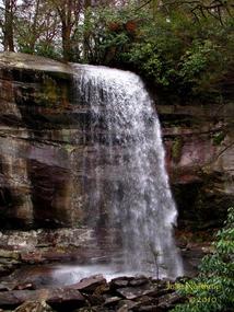
Description: Rainbow Falls Trail is second to Alum Cave in terms of its shorter distance and guest popularity for accessing the lodge. It ascends the northern slopes of Mount LeConte in unrelenting fashion, and was entirely forested until the 2018 firestorm ravaged some of the canopy along the Rocky Spur Ridge. Still, the trail is a beautiful hike through varying forest types as it follows the soothing sounds of LeConte Creek and skirts interesting rock formations higher up with seasonal views.
There are multiple parking lots at the end of Cherokee Orchard Road providing access to the trailhead, the first of which fills up quickly during the busy season. The trail parallels LeConte Creek from the onset, occasionally crossing it over single log footbridges during the first 2.7 miles to Rainbow Falls. The Trails Forever project has already made several improvements to the path here, but please stick to the main path and avoid cutting corners that lead to erosion and de-vegetation. After leaving the famous 75' waterfall, the trail swings away from the creek before returning to it at around 3.0 miles. Use caution, as this unbridged stream crossing can be wet, swift, and hazardous at times of high water. The trail leaves the creek for good after this crossing as it makes its climb up and around the Rocky Spur, crossing the nose of the ridge to the north at just over 3.5 miles. Drainages are notorious for keeping this stretch of trail rather wet for most the year, and the footing can become exceptionally rocky. When you reach the side loop trail for the Rocky Spur Overlook, you are now 1.2 miles from the lodge. The path later swings west and meets the Bull Head Trail below Mount LeConte's West Point. From here, it is a demanding climb the remaining 0.6 of a mile to the lodge. Occasional views to the north offer great opportunities stop and catch your breath. Take a left at the junction with Alum Cave Trail to enter camp and reward yourself with some relaxation after a good climb!
Trillium Gap Trail
Distance: 6.7 miles from Roaring Fork Motor Nature Trail to lodge. 8.9 miles from Cherokee Orchard to lodge.
Elevation: 3,300' up / 100' down
Landmarks: Grotto Falls, Trillium Gap, access to Brushy Mountain summit
Highlights: Pack Llamas three days a week, small creek crossings, impressive stand of Spring Beauties and Trout Lilies at Trillium Gap, can double as a horse trail (day-use only)
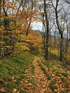
Description: (Roaring Fork is a seasonal road, only open March 29 - December 1 in 2024). When guests ask about the easiest trail for climbing Mount LeConte, there is no right or wrong answer. Alum Cave Trail is the shortest, but the steepness and exposed cliffs can be a deal breaker for some. Trillium Gap Trail provides visitors with a friendly alternative. It is the most gradual ascent of the mountain and is entirely forested without having to navigate exposed rock ledges. It's also the supply line for our pack llamas three times a week, so there's an opportunity to see our favorite fuzzy friends! If you see the llamas on trail, please pay careful attention to the advice of the wranglers responsible for getting the animals to and from the mountain safely.
The most commonly used trailhead is found at the apex of the one-way Roaring Fork Motor Nature Trail (known as the Grotto Falls parking lot), leading hikers to the summit in 6.7 miles. Parking here is limited and fills up quickly during the busy season, often forcing visitors to park further down the road. The trail's true trailhead is back with Rainbow Falls in Cherokee Orchard, increasing the total distance to the lodge at 8.9 miles. Please read and follow signs thoroughly so as not to take the longer trail by mistake!
The first 1.3 miles leading up to Grotto Falls are gradual, wide, and mostly smooth. It's also one of the busiest stretches of trail in the park because of its popularity. Use caution around the falls, especially during times of high water or freezing temperatures which causes rocky surfaces to become slick. Shortly past the falls, the crowds and noise diminish significantly. The forested ascent continues moderately on its way to Trillium Gap at 3.1 miles. From the junction with Brushy Mountain, turn right and uphill to proceed to the lodge. Hikers will soon cross several drainages and parts of the trail become rocky. The trail makes a hard switchback beside a slender cascade 2.25 miles from the lodge. Cove hardwoods slowly transition into spruce-fir forest. The next major switchback occurs within 1 mile of the lodge, where the trail rises sharply while encircling a large collection of split rocks. During this home stretch, you'll pass over a long run of wooden logs holding the trail together. Ice can build up in this area, so use caution and take advantage of the cable for a hand hold. In the last 0.1 of mile before reaching camp, you'll pass the horse hitching post on your right and the natural flowing spring on your left. Proceed beneath the Dining Hall and then left up hill to reach the office for guest registration.
Bull Head Trail
Distance: 6.9 miles from Cherokee Orchard to lodge.
Elevation: 4,000' up / 150' down
Landmarks: The Pulpit
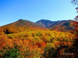
Highlights: Views over the West Prong and Tennessee Valley, spring and summer wildflowers, exposed rock formations
Description: This trail is best accessed from the Rainbow Falls parking lot in Cherokee Orchard. It's slightly longer than its neighbor and not nearly as popular. Recently reopened after the November 2016 fires, it makes for a great loop hike for visitors going to the lodge also looking for something different on the return. Due to its southwest exposure, it's notoriously the hottest trail on the mountain, so hikers may find it easier for means of descent. Before the firestorm took its toll, Bull Head was by far one of the Smokies' best spring wildflower trails. Throughout the month of April, hikers could enjoy an array of wildflowers in bloom from top to bottom.
From Cherokee Orchard, head west 0.4 of a mile along the Old Sugarlands Road before taking a left at the junction with Bull Head Trail. A single log footbridge allows hikers to cross LeConte Creek safely before initiating the 4,000' climb to the lodge. The first mile out of the junction is a gradual climb, but eventually ramps up as it navigates the slopes of Bull Head. Dogwood, Silverbell, and Magnolia fill the canopy with white blooms in spring. In roughly 1.75 miles from the parking lot, the trail passes below identical bluffs that split a drainage. Conditions here are optimal for plant growth, as White Trillium with leaf spreads larger than dinner plates flourish. Approaching 2.5 miles, the trail will have plateaued as it skirts the pine forested summit of Bull Head. This is when temperatures tend to get their hottest. At 2.8 miles you will reach "The Pulpit," a rock table constructed by the Civilian Conservation Corp offering partially obstructed views from the ridgeline. It's a steady climb from here to the crest as the trail works its way around massive Balsam Point. Occasional views are to be had where the path crosses finger ridges, intermixed with small crossings of the headwaters of Big Branch in several drainages. A rise in elevation runs in conjunction with an increase in Red Spruce and Rhododendron. Upon reaching the crest of the mountain, hikers will have earned a reprieve from the long ascent, now just 1.75 miles from the lodge. The trail is fairly level as it crosses to the north side and traverses West Point. Spring Beauties and Trout Lilies dominate in the spring, and Turks Cap Lilies proliferate in the summer. As if you hadn't already done enough, it's another 0.6 of a mile up from the junction with Rainbow Falls to the lodge.
Brushy Mountain Trail
Distance: 9.1 miles from Greenbrier Road terminus to lodge.
Elevation: 4,600' up / 100' down
Landmarks: Old Homestead, Trillium Gap, access to Brushy Mountain summit
Highlights: Porters Creek, spring wildflowers
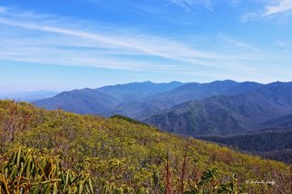
Description: The least used and unofficial sixth trail accessing Mount LeConte, this trail is more for the repeat visitor looking to change things up. The longest of the main routes approaching the lodge, it also gains the most in elevation, but not as steeply as some of its counterparts. The trek begins along Porters Creek Trail out of Greenbrier, with the first mile of hiking coming easily along the wide, gravel path. Upon reaching the old homestead, locate the sign for Brushy Mountain Trail at the back of the turnaround as it breaks right and away from the creek. The next 4.5 miles from here to Trillium Gap start gradually then increase progressively, but never steeply. The forest under-story is very open and airy, once dominated by expansive stands of Hemlocks now dying back and sometimes falling across the trail. White and Yellow Trillium thrive here during the spring months. Views are seasonal, with hikers being afforded glimpses of Greenbrier Pinnacle to the northeast and eventually the heath dome of Brushy Mountain to the west. Take your time with footing when crossing Trillium Branch, or take a cool dip in its shallow pool before proceeding. In spring, an increase in abundance of Spring Beauties and Trout Lilies will signal your upcoming arrival at Trillium Gap. From here, it's 3.6 miles more to the left on your way to the lodge. For an extra 0.8 of a mile roundtrip, include a visit to the summit of Brushy Mountain uphill and to the right. 180° views from the heath covered bald rival any in the Smokies, especially on a clear day. Mountain Laurel and Galax are prolific here. For the remaining 3.6 miles to the lodge, see the trail description for Trillium Gap Trail.
