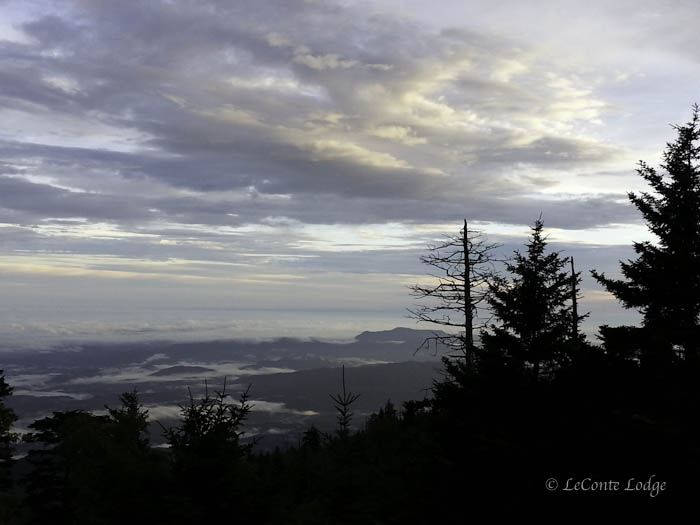
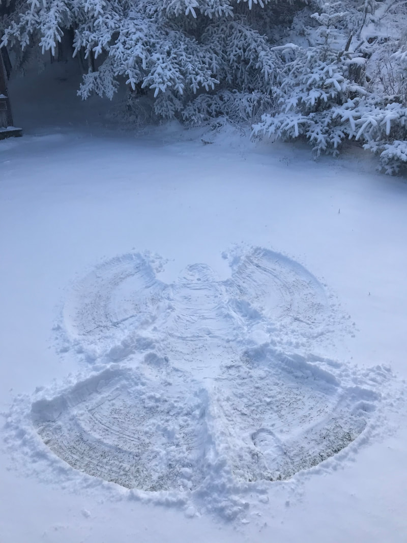
Chris and I made it back up the mountain to a warm day up top. The high yesterday was 70º with a low of 52º. We did see some rain off and on through out the night. The rain gauge read .83" for the day. Today looks as though it will be a repeat of yesterday.
I am going to try and get Ruthie started on the blog in the next couple of days. I know you will enjoy reading her tales of training and learning the ropes. She is a quick learner and seems to have the basics down. As she will learn, there are always little things that need to fixed around the lodge. Chris has already taught her how to use a drill. That is a step in the right direction. She will have her own tool belt before she knows it.
Scott
9/3/2014 01:04:11 am
Hi, Allyson
James
9/3/2014 06:34:56 am
Will be hiking up next Tuesday for an overnight stay. Plan on taking Rainbow falls up if weather permits. Will be first time for me and my wife up to the lodge. Looking forward to it. Any advice from you hikers.
tomk in SC
9/3/2014 08:16:44 am
1) Start early so you have lots of time at the lodge!
James
9/3/2014 09:34:21 am
Thanks tomk.wil do.
Tony Ga
9/3/2014 11:26:54 am
Nice.
elaine
9/3/2014 01:56:26 pm
Very good advice, TomK. Thanks from the rest of us. 9/3/2014 09:54:32 am
Glad you made it back up just fine. I would love a warm mountain day instead of the heat we are facing in Texas.
Kent
9/3/2014 10:14:00 am
I have tentative plans to make it back down to the Smokies on November 13, and am thinking of a night in the shelter. A little snow and azure skies would be most welcome. The last time I experienced those conditions was in 2012 a little over a week after the Halloween snow event. : )
norman
9/3/2014 11:53:13 am
just put Pat's stained glass 'sun' picture as wall paper > sure brighten up things < rain here in Ga. For about the past year, I've been hearing about the Rainbow Falls trail being impassible in heavy rain conditions. Someone on this site said they had to turn back and go back to the Lodge. I don't want to contradict anyone or create unpleasantness, but that is a small stream---admittedly, it could get tougher in high water. What's the story, honestly? I don't believe that stream could be that difficult, but correct me if I'm wrong.
tomk in SC
9/3/2014 12:56:56 pm
On 4 JUL 2013 a group of totally unprepared hikers headed down the RF trail. I was at the top staying overnight. They got to the top late, they left late, they we the standard "A1 Not Ready" group. Well after dark they showed up back at the top reporting the stream impassable (above the falls (I think)). I had the same reaction as you did and asked that somebody take some pictures or look it over and see what's what. What has been reported here has been quite thin. No manpower to head down from the top and nothing from the rangers that I recall. So the best info I have is the info from the merry band of around 8 hikers who were subsequently trapped in nice warm beds at the lodge for the night. The thin info here was along the lines that something about the flow has shifted and things are worse in heavy rains than they have typically been. That makes me second hand having heard it the night it happened. Their poor prep does not mean the stream wasn't flooded, it just means they may not be qualified to assess the stream. I don't recall if they even had flashlights. Debi? Do you recall more details? Allyson was up top that night, she likely remembers it better than I do. Until there is something of a resolution, I wouldn't want to have to hike back down if it WAS impassable.
tomk in SC
9/3/2014 01:47:39 pm
7/22/13 Yeah, my whole thing is to be into challenge instead of caution. As a woman hiking solo a lot of the time, I run into folks pretty often who say, "Be safe." They look concerned about me--I've had people tell me I shouldn't be out by myself. Well, that's fine for them but not for me. But the funny thing is, I really don't see how that crossing of LeConte Creek could be that bad. The trail crosses the stream at 4600' above the falls. It is a small stream at that point. I have been up that stream (off-trail, of course, those of you who know me) all the way to the top of LeConte It is a puny stream, nothing like any of the great Smokies streams like Raven Fork or Eagle Rocks Prong. That's just my opinion. I expect most people will disagree with it. --Jenny
Larry O
9/3/2014 02:41:51 pm
The park service has recently posted a very large sign at the top and bottom of the Rainbow Falls Trail warning that the trail is impassible during heavy stream flow and advising people to take the Bullhead Trail instead. I doubt that they did this based on rumors. tomk and Jenny B, and all others who post very good advice on this site, I commend you. It's what makes up the solid core of this blog and everyone who reads it and follows it surely must be better for it. Yes, it's the "challenge" part that makes it worthwhile. After all, it's the journey that's the destination ! Good evening all.
judy
9/4/2014 05:06:52 am
prayers going out for you Doug.
elaine
9/4/2014 07:30:03 am
Hope that all went well with your surgery today, Doug Y. We look forward to getting you back on the blog and hking the trails once again!
kat
9/3/2014 03:27:45 pm
I have friends who are members of the 900 club. They went up Bullhead, spent the night and headed down Rainbow.They got just above the falls and had to turn around, hike back to the junction of Bullhead and Rainbow and take Bullhead back to the parking lot. This happened on a weekend last year when it had rained for several days. They are experienced hikers and used to creek crossings and rock hopping, and have hiked in rainy weather many times. They said it would have taken a fool to try to cross in a flood like that. When I came down Rainbow in May of this year that crossing was bone dry. My friends had went up Rainbow in order to get the part they had missed for completion of that trail for 2 of them I met them on top, they told me how to locate the spot right above the falls where they had to turn around and they told my there was not a drop of water there. My opinion is to listen to staff and rangers they know what they are talking about
kat
9/3/2014 03:34:19 pm
By the way it is just above the falls and in dry weather just looks like a rocky gully no sign of a stream or creek at all so if you are looking at water areas you may be missing the spot totally. Maybe the water cuts over into the trail in heavy rain
tomk in SC
9/4/2014 12:58:43 am
That's why I think you are the one to get photos! Wait for something that looks monsoonish and head up there yourself. I suppose to be a scientist about it, one would have to wait for something that replicates the weather approaching 4 JUL 2013. Presaturated ground and several days of rain with mountaintop accumulations of (whatever inches it was then). Then snap some pictures. It might be interesting to take your favorite neophyte with you and see if there is any sheer stark terror in their eyes at the prospect of crossing. I keep forgetting to look downstream at the above falls crossing. . .could one be washed over the falls? I do not believe it has ever happened, but if something about the streams has shifted. . .
tomk in SC
9/4/2014 01:41:06 am
I looked at the topo again, and as one hikes DOWN the RF trail, there are actually THREE crossing above RF. The first one one would encounter actually crosses LeConte Creek. That is my favorite suspect for where there might be a problem, and the crossing is quite a ways above RF. If one fell in there, they would likely have time to escape or die before going over the falls, The next two crossings are crossings of the second tributary from the top that joins LeConte Creek. My review of the topo suggests those are unlikely suspects. From the falls going up then, there are two tributary crossings above RF and then the LeConte Creek crossing where I suspect the trouble is.
Steve
9/4/2014 02:55:05 am
To Jenny B. you know this site better than I but I have been reading it for years. I do a lot of backpacking in the Smokies myself, just don't comment because that isn't my thing, just like to read others. I think you have to realize this site is not really for the hardcores because there is a reason these people are hiking to stay at a lodge with others, there are sleeping indoors and having someone cook for them, sorta yuppie hiking. My experiences include shelters and a tent, and solitude, go into the woods to get away from others, not stay with them!! Different worlds. Comments are closed.
|
LeConte LodgeWelcome to the official blog of LeConte Lodge. We hope you find the information provided here both helpful and enjoyable. Thank you for visiting the site, and we hope to see you on the mountain! Archives
June 2024
|
 RSS Feed
|
|
|
|
|
|
