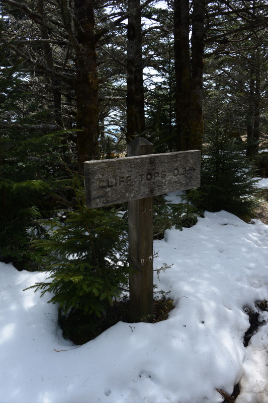
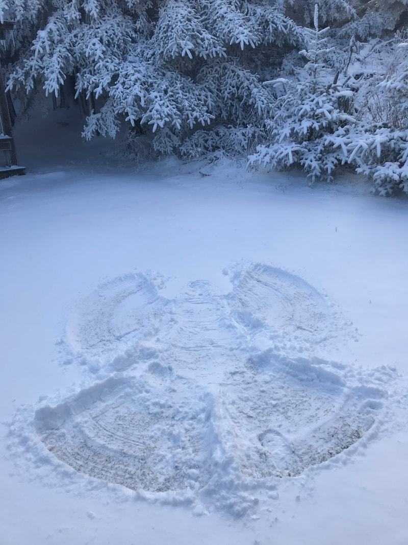
Once again the Leconte weather has changed on a dime. The crew went from wearing snow boots to sandals. They entertained themselves by basking in the warm sun and running the trails around the mountain. It was a pleasant 51º on the mountain. The low only reached 33º. I can feel spring in the air. As you can see from my picture, there is still snow on the ground in places. The reports I have received about the trails are favorable. There will be muddy and icy spots to maneuver around, but I feel it is possible. Some of the park trail volunteers have gone out Boulevard to check on the conditions. I hope to hear from them soon about the shape of the trail. I will pass that along as soon as I hear something. 
Barrie B
4/8/2013 01:06:47 am
Oh my God. I want to be there rather than heading to work.
susan b
4/8/2013 02:43:53 am
Here in Saint Louis, the weather was gorgeous this past weekend. First time to camp and hike and it wiped us out! I don't think it ever did that to us! I couldn't get the 13 year old up this morning and ran us late. Oh well - we shall continue on somehow!
Chris Willertz
4/8/2013 03:14:07 am
We are planning on hiking LeConte Friday, April 12th. There will be eleven of us, father/son hike. Was wondering how treacherous the trail will be? Will be using Rainbow Falls trail. Any info would be appreciated!
ric
4/8/2013 03:55:53 am
went up and down rainbow saturday. pretty muddy till you get to the last 1/2 mile. it was ice covered but should be gone by the 12th - barrring any weather changes so you should have a great walk.
tomk in SC
4/8/2013 04:03:49 am
Rainbow Falls is not even close to treacherous. You have to eat and drink on the way up, but danger is not a factor. If you wanted to get hurt, you might try doing some backflips on the wooden log bridges, or hike up to the falls, get your boots wet and run down to the trail hopping down the rocks. Have lunch below the falls.
ric
4/8/2013 07:04:59 am
a lot of the "splits" are where folks take short cuts either across the flats at the bottom or in cutting off the switch backs. a lot of erosion and a lot of mud from some of them.
Darryl
4/8/2013 03:57:55 am
I, too, was wondering about conditions on the Boulevard aTrail ? thanks.
jay
4/8/2013 06:05:29 am
It will be the last to melt.
tomk in SC
4/8/2013 06:43:44 am
Jenny, wow! I have hiked that segment many times and do not recall being even mildly aware of the possibility of falling. The Jump Off is a potential threat, but that is sort of off trail and folks can stay back as required. I don't know the name of the place on Boulevard, but I believe it is above the rockslide/cable below Myrtle Point, but it seems that a trip forward, when descending, would launch one into oblivion. Ascending, one turns left and steps up onto rocks. It is an easy step, but the over the shoulder view is a bit scary. Yeah, I'm very familiar with the section of Alum Cave with the cables, having climbed up to that point off-trail from Trout Branch a couple of times. Perhaps I call attention to the Boulevard trail because people aren't so tuned into it, especially the steep sidehill portion.
Dan the Bear
4/8/2013 04:46:00 am
We took Rainbow Falls Trail a week ago last Thursday after the 18 inch snowfall. It took us 8 hours to reach the lodge. But it was a magnificent hike--the sun was shinning brightly and not a cloud in the sky.
Nathan
4/11/2013 04:53:01 am
That civilization was 2500 years ago I think it was number one.
doug y
4/8/2013 08:04:39 am
For some time now there have been recommendations and suggestions posted here discouraging hikers to not take the Boulevard Trail. Good advice. It is definitely not a route for inexperienced and ill-prepared individuals and groups. First of all, if your hike begins from the popular and idllyic Newfound Gap, one has an approximately 2.7 mi walk to where the Boulevard turns left off the A. T., then there's another 6.0 mi + or - to Leconte Lodge, and it lives up to its present "rugged" designation, as I re-familarized myself with it a few days ago. It's certainly a bit improved by today. I always enjoy the short side trail to the Jumpoff, but I passed it by this time as I saw that my trail time would be longer. Great Galloping Gertie !! I have to give in a wee bit more to the years !! But I'll never, ever submit to discouragement , despite all the blow-downs, "bad" spots, and other trail conditions. Perhaps my stubbornness will be the end of me some day, but I'll hike on . . . . .On this trip I carried a single old 7.5 min topographic contour map, very old indeed, and discovered several omissions, errors, and mistakes on it that perhaps a new, updated and revised topo map would have corrected. Old names, interesting vantage points, and such. (I remember paying only $0.50 for each of these old topos, now several dollars; Like I said: A lot of years !) For example: Walker Camp Prong (near the ridge top) which is situated below Anakeesta Knob, south of the trail, and above Rt 441 below Newfound Gap on the north side of the 'man ridge', is a bit challenging. This is where in the winter of early 1970 an Explorer Scout lost his life during bitterly cold weather; {his frozen body was found a few days later}. This was less than a year since I had assisted in the massive search for the lost 7-yr-old boy, and no trace ever found, in the Spence Field area further to the S.W. along the A.T., and that was in the summer. So, yes, the Boulevard is challenging and the advice to avoid it is spot on. It remains a great route, with the pink turtleheads and yellow-flowered Clintonian blooms, many varieties of trees, especially the red spruces and Fraser firs with their shallow root systems which can explain why there are so many blow downs on this trail. When there's no snow, and that could be the present case somewhat, one can notice rust-colored or yellowish streaks in some of the rocks around Anakeesta Ridge. This is iron pyrite, "Fool's Gold", This is also an area of landslides. I wanted also to detour for a stop at Myrtle Point, but time was against me as I was descending on the Trillium trail. In fact, I kept on going right past the lodge and when I got to Grotto Falls darkness had fallen. I hiked that last 1.5 mi and the ~1.7 mi over to the Rainbow trailhead with my trusty headlight showing the way. I'll have to re-take this hike sometime this summer. Afterall, the Journey is the destination !! G'day.
Tony Ga
4/8/2013 11:28:00 am
We hiked the Boulevard Trail up to LeConte and down Alum last summer. Our favorite hike to the lodge so far.
shirley Felts
4/8/2013 08:12:07 am
my daughter, two friends, and i are going to hike Mt Leconte tomorrow. it's the first for all of us but my daughter. looking so forward to it!
shirley felts
4/10/2013 11:43:50 am
well, i made it! we took the Alum Cave trailhead. going up was tough, but not too terribly bad til we got to the icy spots near the top. thanks to a great looking, kind guy for helping me across! but on the way down is where i encountered problems. the high steps from big rocks or roots began after awhile to jar and work on my left knee. long before we got to the bluff i was hobbling. i had an ace bandage, but it wound up in the backpack we didn't think we'd need! yeah. right. we took a light weight jacket of my daughter's and tied it as tight as we could around my knee. it helped some, but not enough to speed me up much! i never would have made it without my companions, and prayers. the later it got, the more worried we got, about my knee really debilitating me to the point of having to be carried out, and about not getting off that trail before dark-thirty. we began to whisper little prayers; 'let the knee get better', 'let us make it to the bluffs', then 'let us make it to the stairway thru the rock', then 'please let someone loan us a flashlight!' about a mile from the end....now really getting dark.. as we kept saying, 'we've gotta be near the trailhead', this couple came up behind us who worked at the lodge. bless them! they gave us a flashlight, and told us we were about 3/4 mile out. it felt lots longer as we hobbled along with the light from an iphone and the blessed flashlight! TODAY...i've made a new rule of thumb for hiking; 'not doing a hike that'll put me out of commission for a day afterward. been on ice packs, popping advil and bayer all day. BUT still, I MADE IT! one thing off this 72 yoa woman's 'bucket list'! i mean it's REALLY checked off! can't see myself doing that again. STILL i'm glad i did it! happy hiking, yall!
Debi
4/8/2013 12:12:52 pm
Looks pretty nice up there, enjoy!
jack
4/8/2013 12:53:58 pm
What's the day the Roaring Fork Motor Nature Trail reopens ?
Steve D
4/8/2013 01:18:50 pm
4/12 Comments are closed.
|
LeConte LodgeWelcome to the official blog of LeConte Lodge. We hope you find the information provided here both helpful and enjoyable. Thank you for visiting the site, and we hope to see you on the mountain! Archives
June 2024
|
 RSS Feed
|
|
|
|
|
|
